CQ.CQ

Friday, December 5, 2008

gps system

What is GPS?


The Global Positioning System (GPS) is a satellite-based navigation system made up of a network of 24 satellites placed into orbit by the U.S. Department of Defense. GPS was originally intended for military applications, but in the 1980s, the government made the system available for civilian use. GPS works in any weather conditions, anywhere in the world, 24 hours a day. There are no subscription fees or setup charges to use GPS.

How it works

GPS satellites circle the earth twice a day in a very precise orbit and transmit signal information to earth. GPS receivers take this information and use triangulation to calculate the user's exact location. Essentially, the GPS receiver compares the time a signal was transmitted by a satellite with the time it was received. The time difference tells the GPS receiver how far away the satellite is. Now, with distance measurements from a few more satellites, the receiver can determine the user's position and display it on the unit's electronic map.

A GPS receiver must be locked on to the signal of at least three satellites to calculate a 2D position (latitude and longitude) and track movement. With four or more satellites in view, the receiver can determine the user's 3D position (latitude, longitude and altitude). Once the user's position has been determined, the GPS unit can calculate other information, such as speed, bearing, track, trip distance, distance to destination, sunrise and sunset time and more.

How accurate is GPS?

Today's GPS receivers are extremely accurate, thanks to their parallel multi-channel design. Garmin's 12 parallel channel receivers are quick to lock onto satellites when first turned on and they maintain strong locks, even in dense foliage or urban settings with tall buildings. Certain atmospheric factors and other sources of error can affect the accuracy of GPS receivers. Garmin® GPS receivers are accurate to within 15 meters on average.
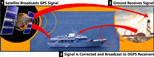
Newer Garmin GPS receivers with WAAS (Wide Area Augmentation System) capability can improve accuracy to less than three meters on average. No additional equipment or fees are required to take advantage of WAAS. Users can also get better accuracy with Differential GPS (DGPS), which corrects GPS signals to within an average of three to five meters. The U.S. Coast Guard operates the most common DGPS correction service. This system consists of a network of towers that receive GPS signals and transmit a corrected signal by beacon transmitters. In order to get the corrected signal, users must have a differential beacon receiver and beacon antenna in addition to their GPS.
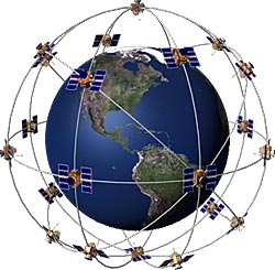
The GPS satellite system

The 24 satellites that make up the GPS space segment are orbiting the earth about 12,000 miles above us. They are constantly moving, making two complete orbits in less than 24 hours. These satellites are travelling at speeds of roughly 7,000 miles an hour.

GPS satellites are powered by solar energy. They have backup batteries onboard to keep them running in the event of a solar eclipse, when there's no solar power. Small rocket boosters on each satellite keep them flying in the correct path.

Here are some other interesting facts about the GPS satellites (also called NAVSTAR, the official U.S. Department of Defense name for GPS):

  • The first GPS satellite was launched in 1978.
  • A full constellation of 24 satellites was achieved in 1994.
  • Each satellite is built to last about 10 years. Replacements are constantly being built and launched into orbit.
  • A GPS satellite weighs approximately 2,000 pounds and is about 17 feet across with the solar panels extended.
  • Transmitter power is only 50 watts or less.

What's the signal?

GPS satellites transmit two low power radio signals, designated L1 and L2. Civilian GPS uses the L1 frequency of 1575.42 MHz in the UHF band. The signals travel by line of sight, meaning they will pass through clouds, glass and plastic but will not go through most solid objects such as buildings and mountains.

A GPS signal contains three different bits of information — a pseudorandom code, ephemeris data and almanac data. The pseudorandom code is simply an I.D. code that identifies which satellite is transmitting information. You can view this number on your Garmin GPS unit's satellite page, as it identifies which satellites it's receiving.

Ephemeris data tells the GPS receiver where each GPS satellite should be at any time throughout the day. Each satellite transmits ephemeris data showing the orbital information for that satellite and for every other satellite in the system.

Almanac data, which is constantly transmitted by each satellite, contains important information about the status of the satellite (healthy or unhealthy), current date and time. This part of the signal is essential for determining a position.
Sources of GPS signal errors

Factors that can degrade the GPS signal and thus affect accuracy include the following:

  • Ionosphere and troposphere delays — The satellite signal slows as it passes through the atmosphere. The GPS system uses a built-in model that calculates an average amount of delay to partially correct for this type of error.
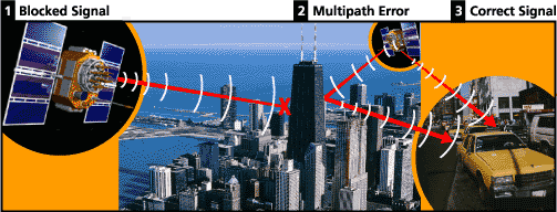
  • Signal multipath — This occurs when the GPS signal is reflected off objects such as tall buildings or large rock surfaces before it reaches the receiver. This increases the travel time of the signal, thereby causing errors.
  • Receiver clock errors — A receiver's built-in clock is not as accurate as the atomic clocks onboard the GPS satellites. Therefore, it may have very slight timing errors.
  • Orbital errors — Also known as ephemeris errors, these are inaccuracies of the satellite's reported location.
  • Number of satellites visible — The more satellites a GPS receiver can "see," the better the accuracy. Buildings, terrain, electronic interference, or sometimes even dense foliage can block signal reception, causing position errors or possibly no position reading at all. GPS units typically will not work indoors, underwater or underground.
  • Satellite geometry/shading — This refers to the relative position of the satellites at any given time. Ideal satellite geometry exists when the satellites are located at wide angles relative to each other. Poor geometry results when the satellites are located in a line or in a tight grouping.
  • Intentional degradation of the satellite signal — Selective Availability (SA) is an intentional degradation of the signal once imposed by the U.S. Department of Defense. SA was intended to prevent military adversaries from using the highly accurate GPS signals. The government turned off SA in May 2000, which significantly improved the accuracy of civilian GPS receivers.

Thursday, November 27, 2008

HF BAND CHARACTERISTICS

160 meters (night) 1.8 - 2.0 MHz
A neighbor to the AM Broadcast band, Very similar conditions to what you hear on AM Broadcast, quite localized during the day, with long distance capability at night. During the summer months the long distances at night can be several hundreds of miles and during the winter it can be several thousand miles. Sometimes noise created by static crashes hinder communications in the summer months but very nice in the winter! 80 meters (night and local during the day)3.5 - 4.0 MHz80 Meters is very similar to 160 meters but with greater distances especially at night. 80 tends to be a very reliable band less subject to variations of the sunspot cycle and is used a lot for regular net operations and message handling and "local rag chewing". Again can be very noise prone in the summer static.

60 meters (night and local during the day)5.330.5 - 5.403.5 MHz
40 meters (night and local during the day)7.0 - 7.3 MHz
This is many ham's favorite band. It is always open somewhere. During the summer daytime distances of 300-400 miles and night time distances of 1000 miles are very common. Winter days with 500 miles or more are usual and night time conditions bring DX intercontinental communications. This band is shared with short-wave broadcast from countries outside of North America. Between these interfering signals a ham with a reasonable station can work stations worldwide if you can find a clear spot!. Not as affected by the sunspot cycle as 20-10 meters.30 meters (CW and digital only)10.100 - 10.150 MHzA lot like 40 meters but can only be used on CW and RTTY. No broadcast interference and has slightly longer range than 40 meters. Daytime ranges of 1000 miles are quite common.
20 meters (world-wide day and night)14.000 - 14.350 MHz
Just about all of the serious DXers hang out on 20 meters!This can be a VERY exciting band with some of the best DX found on any band. Around the world daytime communications are generally possible and when the sunspot cycle is peaking 20 can be used around the clock! Not likely to be used for short-range communications. The only way to work someone a few hundred miles away would be scatter or possibly "long path". Ground wave signals of about 50-75 miles might be all you would expect. At the bottom of the sunspot cycle, openings to other continents are short, rare and few and far between.
17 meters (world-wide day and night)18.068 - 18.168 MHz
Band conditions are very similar to 20 meters. This seems to be a very popular band when hams go mobile and lots of fun can be expected.
15 meters (primarily daytime)21.000 - 21.450 MHz
A lot like 20 meters but a bit more flakey.. More influenced by the sunspot cycle. Much less night time activity than 20 meters but at the peak of the sunspot cycle, 15 can provide much greater distances! On the down side, at the bottom of the cycle, 15 may not open for days.
12 meters (primarily daytime)24.890 - 24.990 MHz
Very heavily influenced by the sunspot cycle. At the bottom of the cycle it is suitable only for very short distance ground wave communications only for long periods of time. At the peak of the cycle it is capable of communications over thousands of miles with a minimum of equipment. Another nice mobile band when conditions are right.
10 meters (daytime during sunspot highs)28.000 - 29.7000 MHz
This is the HF band most heavily affected by sunspots and the sunspot cycle and it can be erratic and exciting at the same time with lots of Dx for the qsl hunter or just as a fun band. Minimum power and simple antennas can bring you a hundred countries in a short period of time when the sunspot cycle is rising towards the peak. Five watts or even less can work half way around the earth!. Ground wave coverage is 25 miles or so. Lots of beacon stations worldwide for DX hunters.

Tuesday, November 25, 2008

radio amatur

BAGAIMANA HENDAK MENJADI OPERATOR RADIO AMATUR DI MALAYSIA

Apakah itu Radio Amatur?
Sepuluh Perkara yang anda perlu tahu berkenaan Radio Amatur
(dipetik dari risalah MCMC)

Radio Amatur atapun juga dikenali sebagai “Ham Radio” ialah hobi berkenaan membina, menguji-kaji dan berkomunikasi melalui radio.
Pengguna-pengguna Radio Amatur ini saling berhubung dengan rakan-rakan mereka seluruh dunia melalui beberapa set-set frekuensi radio yang telah ditetapkan.


Bilakah Radio Amatur bermula?

Sejarah Radio Amatur ini telah bermula semenjak perhubungan radio digunakan. Pada tahun 1912, Kongress Amerika Syarikat telah meluluskan undang-undang pertama bagi mengawal selia pemancaran radio di Amerika Syarikat. Bermula 1914, pengguna Radio Amatur telah mula berkomunikasi dan mengadakan satu system penghantaran mesej di antara mereka. Di Malaysia, radio amatur merupakan titik bermulanya perkhidmatan radio komersil.


Apakah yang boleh saya lakukan dengan Radio Amatur?

Tidak seperti teknologi perhubungan lain, Radio Amatur membolehkan anda berhubung dari mana-mana tempat, pada setiap masa! Pada waktu-waktu bencana, Radio Amatur amat berguna, terutamanya kepada agensi-agensi penyelamat. Pada ketika lain, anda juga kadang kala boleh bercakap dengan para angkasawan atau membalikkan isyarat dari bulan! Anda juga boleh menghantar fail ataupun gambar secara digital. Adakah hobi lain yang menyediakan sebegitu ciri sepertinya?

Saya sentiasa sibuk. Adakah saya masih boleh menikmati hobi ini?

Sudah tentu! Hobi ini tidak terikat kepada sesuatu masa, tempat dan pendapatan seseorang. Memandangkan ianya mudah dikendalikan, ramai yang sentiasa sibuk mendapati ianya seronok digunakan dan mengurangkan tekanan selepas seharian bekerja. Anda dan juga keluarga anda juga boleh menikmati dan mempelajari hobi ini.


Apakah perbelanjaan yang diperlukan bagi hobi ini?


Sebuah radio bersaiz telapak tangan yang baru mungkin sama harganya dengan satu TV 19 inci yang berkos rendah. Radio yang lebih besar adalah sama kosnya dengan satu komputer.

Selain dari itu, bahan-bahan pembelajaran berkenaan Radio Amatur adalah berpatutan dan yuran peperiksaan bagi mendapatkan Sijil Perakuan juga adalah rendah.

Secara alternatif, sekiranya anda cenderung untuk menguji-kaji, seperti kebanyakaan pengguna Radio Amatur atau “Ham Radio”, anda boleh membuat unit “Ham Radio” anda sendiri.


Siapa yang boleh membantu saya?
Kelab-kelab Radio Amatur terdapat di seluruh Malaysia dan bersedia untuk membantu anda. Ada di antara kelab-kelab tersebut mempunyai halaman web yang mengandungi maklumat mengenai hobi tersebut.

Bagaimana saya boleh menjadi seorang operator Radio Amatur?

Hanya mereka yang telah diperakukan boleh mengendalikan sesuatu alat Radio Amatur. Bagi mendapatkan Sijil Perakuan, anda haruslah warganegara Malaysia berusia 14 tahun ke atas dan lulus ujian-ujian berikut:

* Ujian Teori Radio dan Kefahaman Peraturan Radio bagi Sijil Perakuan Kelas B; atau

* Ujian Kod Morse dan ujian-ujian teori dan radio di atas bagi Sijil Perakuan Kelas A.


Siapakah yang mengeluarkan Sijil Perakuan itu?

Sijil Perakuan tersebut dikeluarkan oleh Suruhanjaya Komunikasi dan Multimedia Malaysia kepada mereka-mereka yang telah lulus ujian yang diadakan.


Adakah saya perlu membayar yuran?

Ya, Sijil Perakuan tersebut haruslah diperbaharui setiap tahun. Yuran tahunan bagi Sijil Perakuan Kelas A adalah sebanyak RM36 dan bagi Sijil Perakuan Kelas B, yurannya adalah RM24 setahun.


Apakah yang boleh saya pelajari sebagai permulaan?

Anda boleh memulakan pelajaran anda dengan mempelajari fonetiks abjad yang digunakan oleh pengguna-pengguna Radio Amatur di seluruh dunia!
Abjad yang----------------Kod digunakan------------------Cara sebutan
Hendak dihantar
A-------------------------------Alfa--------------------------AL FAH
B-------------------------------Bravo------------------------BRAH VO
C------------------------------Charlie-----------CHAR LEE atau SHAR LEE
D-------------------------------Delta-------------------------DELL TA
E-------------------------------Echo-------------------------ECK OH
F-------------------------------Foxtrot----------------------FOKS TROT
G-------------------------------Golf-------------------------GOLF
H-------------------------------Hotel------------------------HOH TEL
I--------------------------------India------------------------IN DEE AH
J-------------------------------Juliet----------------------JEW LEE ETT
K------------------------------Kilo--------------------------KEY LOH
L-------------------------------Lima------------------------LEE MAH
M-------------------------------Mike------------------------MIKE
N-----------------------------November-----------------NO VEM BER
O------------------------------Oscar------------------------OSS CAH
P------------------------------Papa-------------------------PAH PAH
Q------------------------------Quebec----------------------KEH BECK
R------------------------------Romeo-----------------------ROW ME OH
S-------------------------------Sierra----------------------SEE AIR RAH
T------------------------------Tango-----------------------TANG GO
U------------------------------Uniform------------------YOU NEE FORM
V------------------------------Viktor-----------------------VIK TAH
W-----------------------------Whiskey---------------------WISS KEY
X-----------------------------X-Ray------------------------ECKS RAY
Y-----------------------------Yangkee---------------------YANG KEY
Z-------------------------------Zulu----------------------ZOO LOO

Sunday, November 23, 2008

jenis gelombang

PENYEBARAN GELOMBANG BUMI(Ground Wave Propagation)Penyebaran gelombang bumi melibatkan pemancaran isyarat radio di sepanjang atau berhampiran dengan permukaan bumi. Isyarat gelombang bumi ini terbahagi kepada tiga bahagian iaitu;a. Gelombang Terus (direct wave)b. Gelombang Pantulan (reflected wave)c. Gelombang Permukaan (surface wave)a. Gelombang TerusIa bergerak dari satu antenna ke antenna yang lain yang dikenali sebagai jarak pemancaran atau “line of sight mode”. Jarak maksimumnya bergantung kepada ketinggian antenna dari paras tanah. Semakin tinggi antenna, semakin jauh jarak pemancaran isyarat radio. Oleh kerana isyarat radio bergerak di udara, banyak halangan seperti puncak bukit akan menghalang dan melemahkan isyarat berkenaan. Bagi antenna yang ketinggiannya 10 kaki dari paras tanah, jarak pemancaran maksimum adalah dianggarkan sekitar 5 batu atau 8 km.b. Gelombang PantulanGelombang ini terhasil oleh isyarat radio yang dipancarkan ke antenna penerima memantul ke bumi. Maka, gabungan gelombang pantulan dengan gelombang terus dikenali sebagai gelombang angkasa (space wave).c. Gelombang PermukaanGelombang ini bergerak di sepanjang permukaan bumi. Ia juga dikenali sebagai perhubungan gelombang bumi. Gelombang permukaan bergantung kepada jenis-jenis permukaan bumi di antara kedua-dua antenna. Permukaan bumi yang baik pengalirannya seperti permukaan air laut mampu menyebarkan isyarat radio dengan lebih jauh lagi. Tetapi, bagi permukaan bumi yang tidak sesuai seperti permukaan berpasir atau beku berais, jarak penyebaran isyarat radio adalah dekat. Jarak liputan bagi gelombang permukaan ini juga akan merosot jika permukaan bumi itu ditumbuhi tumbuhan hijau atau kawasan bergunung-ganang.